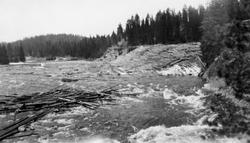
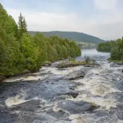
Elv, antakelig Åsta i Hedmark, med tømmerhaug i elveløpet og tømmervelte i elveskråningen til høyre. I elveskråningen skimter vi også en veg som gikk mot den nevnte velta, som var ...
Åsta er ei elv som har sine kilder på kjølen mellom Gudbrandsdalen og Østerdalen. Øver-Åsta og Ner-Åsta kommer begge fra myrområder i den østre delen av Øyerfjellet, drøyt 900 mete ...
Åsta er ei elv som har sine kilder på kjølen mellom Gudbrandsdalen og Østerdalen. Øver-Åsta og Ner-Åsta kommer begge fra myrområder i den østre delen av Øyerfjellet, drøyt 900 meter over havet. Disse to åene renner sammen og får fellesnavnet Åsta. På sin veg sørover får den tilløp fra flere sideløp, som Lyngåa, Hynna og Skolla. Det sistnevnte sidevassdraget møter Åsta like nedenfor Øvre Åstbrua, som ligger lengst nord i Ringsaker kommune. Neste sidevassdrag av en viss betydning er Øyungsåa, som forenes med Åsta ved Bjønnåsbrua, som ligger i Furnes allmenning. Etter noen få kilometer i Furnes dreier Åsta mer østover og inn i Vang allmenning, like før den når Bringbusætra, hvor Kittilåa kommer fra nord. Noen kilometer lenger øst når Åsta kommunegrensa mot Åmot der den forenes med Søndre Djupa ved Djuposet. Derfra renner vassdraget sørøstover til det når Glomma ved den grenda i Åmot som har fått navn etter elva, om lag 200 meter over havet. Åsta er om lag 7 mil lang og har et nedslagsfelt på om lag 650 kilometer. Mye av dette arealet ligger høgt til fjells, i områder der skogen vokser langsomt. Her var det dessuten allmenningsskog, der gardbrukerne i Ringsaker, Furnes og Vang hadde bruksrett på tømmeret. De brukte noe av trevirket på sætrene og kjørte noe av tømmeret mot bygdene sørvest for Åsta. Fra gammelt av ble dette vassdraget fløtet i to avdelinger. Den øverste begynte i traktene vest for Nysætra i Pihlske sameie (Ringsaker) og gikk gjennom de indre skogkledde delene av Furnes og Vang allmenninger fram til Åmot-grensa ved Djuposet, der den nederste avdelingen begynte. Disse to avdelingene spente over en elvestrekning på cirka 3 mil. Det var ikke hvert år det ble levert tømmer fra den øvre delen av den øverste avdelingen. Ifølge oppsynsmann Trygve Solbakken (1903-1983), som hadde tilhold ved Kvarstaddammen og husket forholdene tilbake til omkring 1920, var det gjerne åmotinger som påtok seg fløting også i den øvre avdelingen. Gunnar Sætren (1843-1928), som i 1904 gav ut bok om Glomma og dens sidevassdrag, nevner fire velteplasser (leveringssteder for tømmer) i den øvre avdelingen, 20 i den nedre. Denne forskjellen gjenspeiler nok også volumene på tømmerleveransene, som ble atskillig større på Åmot-sida. Den nedre delen av Åstdalen er trang og bratt, så fra noen av veltene der hendte det at tømmeret ble skadd under utislag. Sætren skriver at «I elven er ingen atholdsdam, hvortil der heller ikke er anledning, før man kommer saa langt op i elven, at dammen neppe vilde være til noget væsentligt gavn for flødningen nedenfor Djuposet.» Dersom denne påstanden stemte, betyr det at Kvarstaddammen må være bygd etter 1900. Om det ble gjort for å gagne fløtinga i den nedre delen av vassdraget, eller om det var allmenningene i Ringsaker, Furnes og Vang som stod bak, er vi ikke sikre på.
SubjectElv, antakelig Åsta i Hedmark, med tømmerhaug i elveløpet og tømmervelte i elveskråningen til høyre. I elveskråningen skimter vi også en veg som gikk mot den nevnte velta, som var plassert i forholdsvis bratt terreng, der tømmeret lett kunne rulle ned mot elva.
Dette fotografiet er fra samlinga etter Glomma fellesfløtingsforening og forløperne, Christiania Tømmerdirektion (Øvre Glommens fællesfløtningsforening) og Fredrikstad Tømmerdirektion (Nedre Glommens fællesfløtningsforening). Da det ble klart at det gikk mot avvikling av fløtinga i Glommavassdraget i midten av 1980-åra initierte Norsk Skogbruksmuseum noe som ble kalt «Prosjekt Glomma». Museet satte historikeren Øivind Vestheim og fotografen OT Ljøstad til å følge fløtinga i vassdraget med kamera de siste to fløtingssesongene, mens museumsdirektør Tore Fossum samarbeidet med administrasjonen og styret i Glomma fellesfløtingsforening om best mulig ivaretakelse av levningene etter den viktige aktiviteten fløtinga hadde vært. En del installasjoner i vassdrag måtte imidlertid fjernes, slik vassdragslovgivningen forutsatte. Mange husvære ble overdratt til grunneiere for en rimelig pris, og noe ble overlatt til aktører som ville drive formidling av vassdrags- og fløtingshistorie. Arkivene etter virksomheten ble overdratt til Riksarkivet, som valgte å la det bli liggende i en av kontorbygningene ved Fetsund lenser. Ordning av dette materialet ble påbegynt under ledelse av Øivind Vestheim. Etter at det ble etablert et museum ved Fetsund lenser i 1990 har personale derfra hatt det daglige forvaltningsansvaret for protokoll- og dokumentarkivet etter Glomma fellesfløtingsforening. Fotomaterialet etter organisasjonen ble overlatt til Norsk Skogbruksmuseum da fløtinga opphørte. Det besto av 72 album, samt en del «løse» kopier og negativer. OT Ljøstad reproduserte mange av motivene ved hjelp av mellomformatkamera med negativ svart-hvitt-film. Materialet ble også enkelt registrert, i første omgang med stikkord (ofte stedsnavn og opptaksdatoer) som var skrevet inn i albumene. Skanning og fyldigere registrering tas innimellom andre oppgaver, og ettersom samlinga er stor, vil det ta lang tid før dette arbeidet er fullført. Norsk Skogbruksmuseum publiserte i 1998 Øivind Vestheims bok «Fløtning gjennom århundrer» hvor mye av materialet fra «Prosjekt Glomma» og fotografier fra Glomma fellesfløtingsforenings arkiv ble presentert.


")

Add a comment or suggest edits
To publish a public comment on the object, select «Leave a comment». To send an inquiry directly to the museum, select «Send an inquiry».