Skådam ved Heggøye, nederst i Månavassdraget i Tinn, fotografert i 1927, antakelig tidlig på våren. I en tekst ved siden av fotografiet heter det nemlig «Reiste i flommen 1927». ...
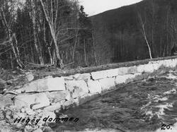
Skådam ved Heggøye, nederst i Månavassdraget i Tinn, fotografert i 1927, antakelig tidlig på våren. I en tekst ved siden av fotografiet heter det nemlig «Reiste i flommen 1927». Det dreier seg om en skådam som var tørrmurt av bruddstein, for å hindre at fløtingstømmeret strøk på land i en yttersving i elveløpet. Under flomvannføring kunne tømmeret lett ha blitt liggende i krattskogen der, slik at fløterne måtte bære det tilbake til hovedløpet, stokk for stokk. Månavassdraget kommer fra Møsvatn iog har et nedslagsfelt på nesten 1 500 kvadratkilometer. Vassdraget var fra gammelt av fløtbart fra den 104 meter høye Rjukanfossen og nedover til utløpet i Vestfjorden, i den nordvestre enden av Tinnsjøen. Dette er en strekning på cirka 19 kilometer. Etter industrialiseringa på Rjukan startet fløtinga lengre nede, ved Svadde-gardene nedenfor industrianleggene og sentrum i tettstedet Rjukan. Dette var en strekning på 12 kilometer med et samlet fall på 65 meter, hvorav den øverste strekningen var den bratteste. Den nedre delen av Måna ble likevel ansett for å være i bra fløtingselv hvor det sjelden oppsto skader på fløtingsvirket. I tiåra etter at Norsk Hydro startet sin store industriutbygging nedenfor Rjukanfossen konsumerte denne bedriften mesteparten av det tømmeret som ble levert i dalføret, og som sørget for det som foregikk av fløting.
SubjectSkådam ved Heggøye, nederst i Månavassdraget i Tinn, fotografert i 1927, antakelig tidlig på våren. I en tekst ved siden av fotografiet heter det nemlig «Reiste i flommen 1927». Det dreier seg om en skådam som var tørrmurt av bruddstein, for å hindre at fløtingstømmeret strøk på land i en yttersving i elveløpet. Under flomvannføring kunne tømmeret lett ha blitt liggende i krattskogen der, slik at fløterne måtte bære det tilbake til hovedløpet, stokk for stokk. Månavassdraget kommer fra Møsvatn iog har et nedslagsfelt på nesten 1 500 kvadratkilometer. Vassdraget var fra gammelt av fløtbart fra den 104 meter høye Rjukanfossen og nedover til utløpet i Vestfjorden, i den nordvestre enden av Tinnsjøen. Dette er en strekning på cirka 19 kilometer. Etter industrialiseringa på Rjukan startet fløtinga lengre nede, ved Svadde-gardene nedenfor industrianleggene og sentrum i tettstedet Rjukan. Dette var en strekning på 12 kilometer med et samlet fall på 65 meter, hvorav den øverste strekningen var den bratteste. Den nedre delen av Måna ble likevel ansett for å være i bra fløtingselv hvor det sjelden oppsto skader på fløtingsvirket. I tiåra etter at Norsk Hydro startet sin store industriutbygging nedenfor Rjukanfossen konsumerte denne bedriften mesteparten av det tømmeret som ble levert i dalføret, og som sørget for det som foregikk av fløting.
Title
«Hegøydammen 26» (Innskrift, utført med svart tusj, på bildeflata)Fotografs tittel
«Reiste i flommen 1927» (Innskrift ved siden av opplimt kopi av fotografiet i rapportdokument.)Fotografs tittel
Dette fotografiet en av flere fotografiske kopier i lite format (cirka 10,5 X 7,8 centimeter) som er innlimt i en kopi av en rapport med tittelen «Tinns vasdrag» som befinner seg i arkivet etter Skiensvassdragets Fellesfløtningsforening (ARK-1044, Db, 55A). Ingeniør og fløtingsinspektør Frithjof Rosnæss har signert rapporten, og det er nærliggende å anta at han også har tatt fotografiene under sine befaringsreiser i fløtingsdistriktet han hadde ansvar for, Øst-Telemark.


")


Add a comment or suggest edits
To publish a public comment on the object, select «Leave a comment». To send an inquiry directly to the museum, select «Send an inquiry».