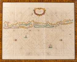
Subject Nederlandsk sjøkart som viser kysten fra Bergen i nord til Skudesneshavn i sør. Perspektivet er sett fra havet i vest. Dekorert med kartroser og skip.
Museet for Søfart i Helsingør har et kart i sitt arkiv med tilsvarende navn. Dette skal ha kommet fra Jacob en Casparus Loots-Man Atlas som ble utgitt i 1680.
Pieter Goos (1616–1675) was a Dutch cartographer, copperplate engraver, publisher and bookseller. He was the son of Abraham Goos (1590–1643), also a cartographer and map seller. From 1666, Pieter Goos published a number of well produced atlases. He was the first to map Christmas Island, which he labelled "Mony" in his map of the East Indies, published in his 1666 Zee-Atlas (Sea Atlas). His Atlas ofte Water-Weereld (Atlas or Water World) has been cited as one of the best maritime atlases of its time. Another of his fine works was the Oost Indien (East Indies) map published in 1680.


Add a comment or suggest edits
To publish a public comment on the object, select «Leave a comment». To send an inquiry directly to the museum, select «Send an inquiry».