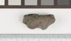
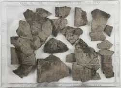
I forbindelse med omreguleringen av deler av Furuset kirke på Furuset øvre 110/1 m.fl. gjennomførte Kulturhistorisk museum en arkeologisk utgravning av planområdet i perioden 06.06-17.06.2011. Akershus fylkeskommune gjennomførte en forundersøkelse av området i 2009, og i den forbindelse registrerte to lokaliteter, et gravfelt ID42218 som er regulert til bevaring i planen, og bosetningsspor ID128825. Utgravningsområdet lå i dyrket mark, og undergrunnen bestod av sand. Til sammen ble det flateavdekt 2135m². Under utgravningen ble det avdekket kokegroper, stolpehull, steinpakning, grøft og nedgravninger med ukjent funksjon. En kokegrop S-5 skilte seg ut ved å innholde fragmenter fra en smeltedigel, et fragment av trolig støpeform, fire, små magnetiske fragmenter av jern og flere biter av sintret/brent leire. Funnene indikerer at det trolig har vært en produksjonsplass i næromerådet, men denne ble ikke funnet. Alle strukturene ble undersøkt. Syv kullprøver er vedartbestemt av Helge I. Høeg ved KHM (2011), og alle er radiologisk datert ved NTNU-Trondheim (Df-4416). Åtte makroprøver er analysert ved NOK av Annine Moltsen (2011), og to mikromorfologiprøver fra samme struktur S-5, er analysert av Dr Richard Macphial (2012). Bein- og tannfragmenter fra en kokegrop er analysert av Sofia Prata ved SAU (2012). Analyseresultat er vedlagt utgravningsrapport (Sæther og Glørstad 2013). Restmateriale fra alle analysene er tilbakesendt KHM.