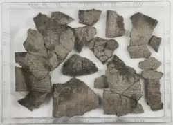
Arkeologisk utgravning av bosetningsspor, grav ogfotgrøfter. Vest-Agder fylkeskommune gjennomførte 19. mars 2002 er registrering av området og gav fornminnet lokalitetsid. 91668. Undersøkelsesområdet ligger i dyrket mark på et høydedrag med utsikt i sørøst ned mot Sangeslandvannet. Rett sør for undersøkelsesområdet skråner terrenget bratt, mens det i nord grenser til riksvei 454 og i vest til kirkegården. Det er registrert to gravfelt nær Øvrebø kirke. På Steinsvollen er det påvist et gravfelt med til sammen 6 gravhauger (lok. Id. 77284) ca 300 m ØNØ for Øvrebø kirke. Feltet ligger på en naturlig forhøyning i et skogholt med utsikt i vest til Øvrebø kirke. På Nordhagen, 47/13, (lok. Id. 39092) ligger et felt med 6 røyser og 2 hustufter. Gravfeltet ligger ca. 500 m VNV for Øvrebø kirke. Det er registrert en rundrøys med antydning til fotgrøft rundt søndre halvdel på Hagåsane (lok. Id. 74285). Røysa ligger vel 550 m øst for Øvrebø kirke. På Prestefjellet ligger det en bygdeborg (lok. Id. 9674), 250 m VNV for undersøkelsesområdet. Et område på ca 40 x 50 m ble undesøkt ved maskinell flateavdekking. Det ble påvist bosetningsspor i form av stolpehull, kulturlag, ildsteder og kokegroper. En grav med tilhørende stolpehull og to fotgrøfter ble også undersøkt.