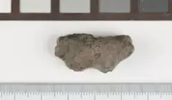
aboutMørkebrunt, tykt og mellomgrovt magret skår. Randen er jevnt avrundet. Innsiden glatt. Utsiden sintret og dekt med bobler som tyder på sterk varmepåvirkning. Uornert.
Det aktuelle planområdet omfatter den nordre delen av et flatt parti dyrket mark som i sør avgrenses av E39, i vest av Mandalselva og Rv 455 mot Øyslebø. Mot nord er området avgrenset av gårdsvei og et fjellområde, mens det i øst er avgrenset av gårdsvei og boligbebyggelse. Undersøkelsesområdet ble avdekket ved hjelp av maskinell flateavdekking. Funn fra nedgravninger påvist under flateavdekkingen er katalogisert under C54246/1-5. Forut for flateavdekkingen ble omlag 70 1x1 m ruter med pløyelagsmasser, som var jevnt fordelt ut over hele undersøkelsesområdet, såldet maskinelt. Funn fra såldingen er katalogisert under C54247/1-58, som løsfunn. Området var på omlag 7 daa.