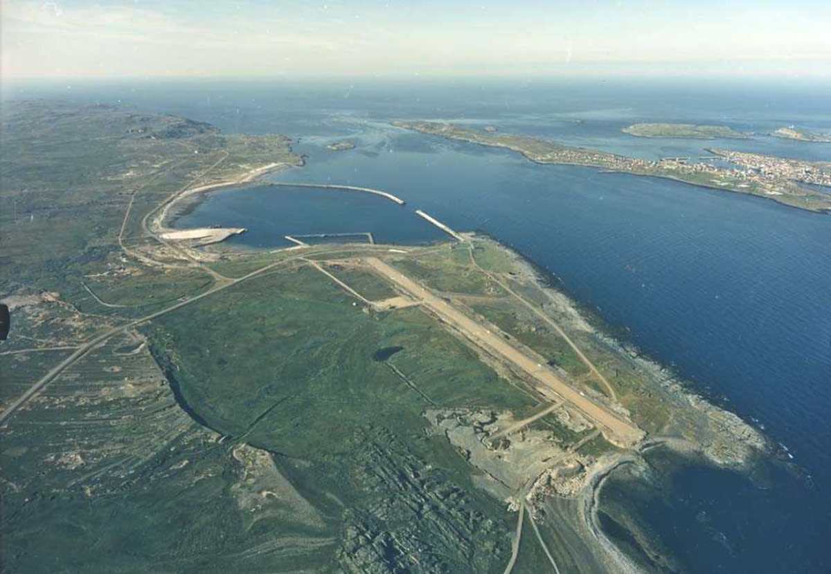
Photo: Norsk Luftfartsmuseum (Opphavsrett) Lufthavn/Flyplass. ENSS-VAW. Vardø/Svartnes. Oversiktsbilde over flyplassen, topografien rundt og byen. Baneretning/RWY 15/33. icon--add Add to folder icon--add Add to folder Remove from folder Order image 0 Comment/inquiry social--facebook social--more Share About the object Identifier NL.07040798 Avbildet sted Norge Finnmark Vardø sikker Specific subject terms Flyplass Subject Lufthavn/Flyplass. ENSS-VAW. Vardø/Svartnes. Oversiktsbilde over flyplassen, topografien rundt og byen. Baneretning/RWY 15/33. Type Photograph Created with Sketch. Add a comment or suggest edits History Eierskap Giver/siste eier Widerøes Flyveselskap A/S sikker Fotografering - 1993 — 1996 Avbildet sted Norge Finnmark Vardø sikker Created with Sketch. Add a comment or suggest edits Classification Fotografering OU 215 License information License Copyright Metadata Copies 1 Positivkopi, farge, Arkivkopi Identifier NL.07040798 Part of collection Norsk Luftfartsmuseum Owner of collection Norsk Luftfartsmuseum Institution Norsk Luftfartsmuseum Date published December 18, 2014 Date updated June 2, 2016 DIMU-CODE 021015692406 UUID da1533ca-029c-4217-a1ee-d62f0c7c8891 Tags For adding tags, log in. There are 1,172 results for «Flyplass» in Norsk Luftfartsmuseum: Trondheim Fk.s Bergfalke II/55 og Piper Cub og Luftforsvarets Saa... Trondheim Fk.s Baby IIB lastet på henger. Bak ses Røros flyplass ... Stang, Johan Det britiske flyet Handley Pag... Stang, Johan Det britiske flyet Handley Pag... Stang, Johan Det britiske flyet Handley Pag... View more Add a comment or suggest edits To publish a public comment on the object, select «Leave a comment». To send an inquiry directly to the museum, select «Send an inquiry». Leave a comment or send an inquiry You are not logged in – Log in You are not logged in – Log in Your name Your email Add comment or cancel Send an inquiry Your message will be sent to Norsk Luftfartsmuseum. Recipient Message You are not logged in – Log in Your name Your email Send email or cancel New comment or inquiry


Add a comment or suggest edits
To publish a public comment on the object, select «Leave a comment». To send an inquiry directly to the museum, select «Send an inquiry».